Moore’s paper and accompanying blog posts cover aspects of military cartography from mapping enemy trench lines, layouts of minefields, naval blockade zones, interpreting aerial photography, and more. The information is interesting and the maps are fascinating. Take a look.
Map from “Cartographies of Time” courtesy of Princeton Architectural Press.
We at the The Dupuy Institute love infoporn, those amazing, information-laden graphics that at once render dense, complex topics instantly understandable to the masses. Wired,Jalopnik, and Gizmodohave tags dedicated to sharing the best examples of it. Wiktionary defines infoporn as “Information which does not serve a purpose other than to hold the attention of its audience; information for information’s sake.” Perhaps so, but we at TDI feel that beauty is in the eye of the beholder.
Betsey Mason, a co-author of National Geographic‘s All Over The Map blog, has a profile of one of the greatest purveyors of infoporn, Charles Minard. Minard created what is considered by many to be the iconic work of information graphics, “Napoleon’s March,” or “the Minard graphic.” Created in 1869, Minard’s map depicts Imperial France’s doomed 1812-13 invasion of Russia. It traces the advance and catastrophic retreat of Napoleon Bonaparte’s Grande Armee, while simultaneously showing its gradually dwindling manpower. At age 88, Minard conveyed an essential understanding of the subject with an imaginative combination of spacial and quantitative information that continues to resonate and astonish nearly a century and a half later.
As Mason writes,
Today Minard is revered in the data-visualization world, commonly mentioned alongside other greats such as John Snow, Florence Nightingale, and William Playfair. But Minard’s legacy has been almost completely dominated by his best-known work. In fact, it may be more accurate to say that Napoleon’s March is his only widely known work. Many fans of the March have likely never even seen the graphic that Minard originally paired it with: a visualization of Hannibal’s famous military campaign in 218 BC, as seen in the image [above].
Go check out the full article and marvel at the power of infoporn.
The joint U.S. Army/U.S. Marine Corps white paper, “Multi-Domain Battle: Combined Arms for the 21st Century,” dated 24 February 2017, outlining their initial thoughts on the concept is available online at the U.S. Army Training and Doctrine Command (TRADOC) website.
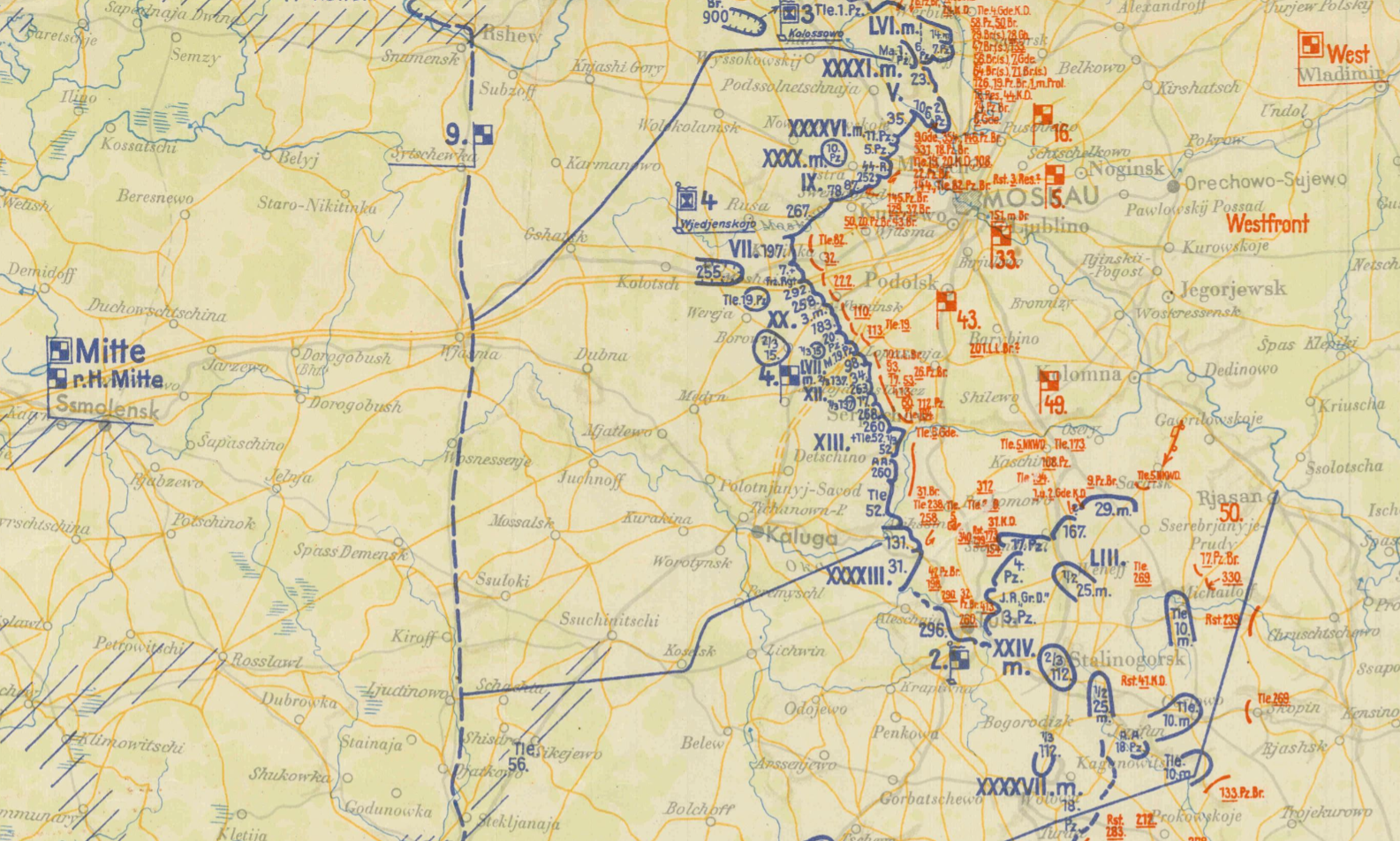
The situation in Army Group Center’s sector of the Eastern Front on 6 December 1941. [National Archives]
The Special Media Archives Services Division of the National Archives and Records Administration (NARA) in Washington, D.C. announced on it’s blog, The Unwritten Record, the recent opening of two new series in Record Group 242: National Archives Collection of Foreign Records Seized. The new series are German Situation Maps of the Western Front, 1944-1945 (NAID 40432392) and Various German World War II Maps, 1939-1945 (NAID 40480105).
The collections contain photographic reproductions of a full map of Germany including how many states in Germany existed at the time, as well as reproductions of various daily situation report maps created by the Oberkommando der Wehrmacht (Armed Forces High Command) and Oberkommando des Heeres (Army High Command) to brief Adolph Hitler and senior German leaders. They show friendly (blue) and enemy (red) forces down to the division and detachment level. The original maps were captured by U.S. forces, which were later duplicated and then returned to the Germans.
Maps. Beautiful Maps
The NARA blog post includes several wonderful, high-quality digital scans in JPG format, although a quick check of the online NARA catalogue shows that these digital maps have yet to be posted online. As the existence of the images in the post show, however, this cannot be too far behind.
The maps themselves are priceless historical records containing truly amazing amounts of information. A portion of the Lage Ost (Situation East) map for 6 December 1941, above, is particularly notable. It depicts the military situation at what can be argued as the high tide of German fortunes in World War II, with its forces closing in on Moscow. However, 6 December was also the beginning of the great Soviet winter counteroffensive that would drive the German Army permanently away from Moscow.
A Map Is Worth At Least A Thousand Words
Several details immediately jump out. The northern prong of the German offensive, led by the Third Panzer Group and Forth Panzer Group, and the southern thrust by the Second Panzer Army can be clearly seen. While Second Panzer Army’s divisions are concentrated for the push from Tula northward, the army’s eastern flank is merely screened by elements of the 10th and 25th Motorized Infantry divisions, the 112th Infantry Division, and a detachment of the 18th Panzer Division. Large-scale, abstract maps of the war on the Eastern Front often depict the battle lines as solid, when in fact, they were thinly-held or gapped.
This is significant because of what this map does not depict: the several dozen divisions the Soviets had amassed around Moscow for their counter-offensive. In fact, the first Red Army counterattacks had started on 5 December, against the LVI Panzer Corps, north of Moscow (at the top of image above). Soviet maskirovka, or military deception efforts, had successfully hidden the build-up from German intelligence, surveillance, and reconnaissance assets. Soviet troops infiltrated these gaps, forcing the Germans to halt their attack and then withdraw to avoid encirclement.
This is only a fraction of the story contained in these maps. Hopefully, NARA is diligently digitizing the rest of the collection and will get them online as soon as possible,
Trevor N. Dupuy, Numbers, Predictions and War: Using History to Evaluate Combat Factors and Predict the Outcome of Battles (Indianapolis; New York: The Bobbs-Merrill Co., 1979), p. 79
Is there actually a reliable way of calculating logistical demand in correlation to “standing” ration strength/combat/daily strength army size?
Did Dupuy ever focus on logistics in any of his work?
The answer to his first question is, yes, there is. In fact, this has been a standard military staff function since before there were military staffs (Martin van Creveld’s book, Supplying War: Logistics from Wallenstein to Patton (2nd ed.) is an excellent general introduction). Staff officer’s guides and field manuals from various armies from the 19th century to the present are full of useful information on field supply allotments and consumption estimates intended to guide battlefield sustainment. The records of modern armies also contain reams of bureaucratic records documenting logistical functions as they actually occurred. Logistics and supply is a woefully under-studied aspect of warfare, but not because there are no sources upon which to draw.
As to his second question, the answer is also yes. Dupuy addressed logistics in his work in a couple of ways. He included two logistics multipliers in his combat models, one in the calculation for the battlefield effects of weapons, the Operational Lethality Index (OLI), and also as one element of the value for combat effectiveness, which is a multiplier in his combat power formula.
Dupuy considered the impact of logistics on combat to be intangible, however. From his historical study of combat, Dupuy understood that logistics impacted both weapons and combat effectiveness, but in the absence of empirical data, he relied on subject matter expertise to assign it a specific value in his model.
Logistics or supply capability is basic in its importance to combat effectiveness. Yet, as in the case of the leadership, training, and morale factors, it is almost impossible to arrive at an objective numerical assessment of the absolute effectiveness of a military supply system. Consequently, this factor also can be applied only when solid historical data provides a basis for objective evaluation of the relative effectiveness of the opposing supply capabilities.[1]
His approach to this stands in contrast to other philosophies of combat model design, which hold that if a factor cannot be empirically measured, it should not be included in a model. (It is up to the reader to decide if this is a valid approach to modeling real-world phenomena or not.)
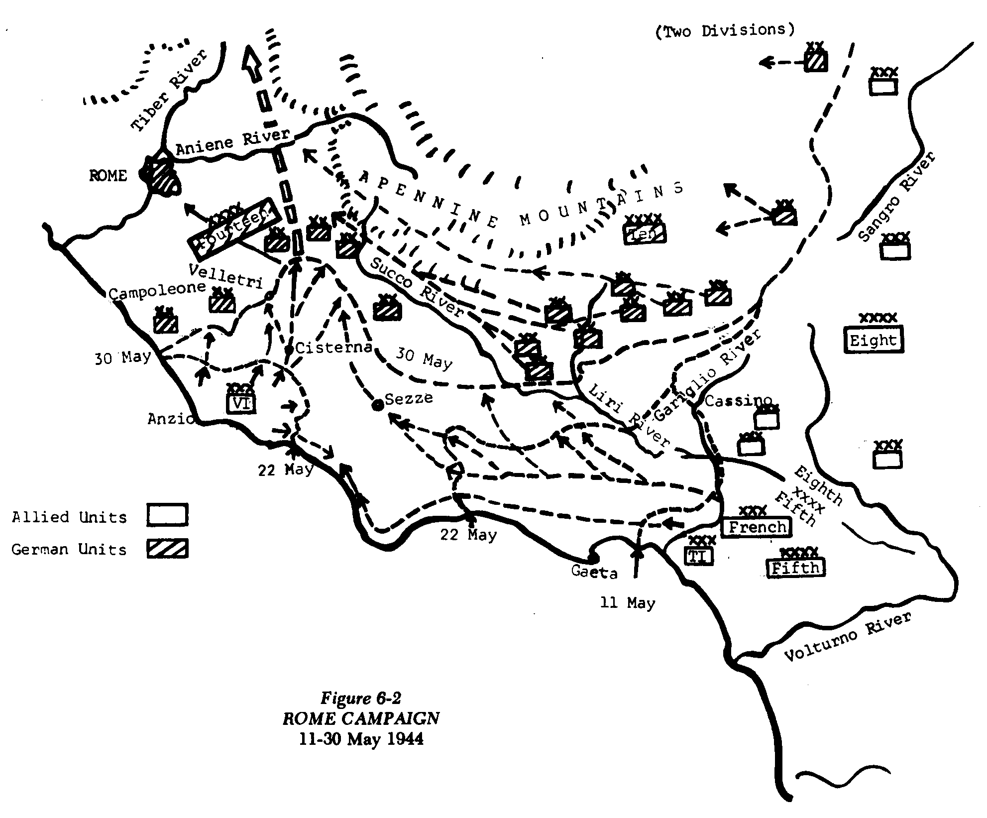
Yet, as with many aspects of the historical study of combat, Dupuy and his colleagues at the Historical Evaluation Research Organization (HERO) had taken an initial cut at empirical research on the subject. In the late 1960s and early 1970s, Dupuy and HERO conducted a series of studies for the U.S. Air Force on the historical use of air power in support of ground warfare. One line of inquiry looked at the effects of air interdiction on supply, specifically at Operation STRANGLE, an effort by the U.S. and British air forces to completely block the lines of communication and supply of German ground forces defending Rome in 1944.
Dupuy and HERO dug deeply into Allied and German primary source documentation to extract extensive data on combat strengths and losses, logistical capabilities and capacities, supply requirements, and aircraft sorties and bombing totals. Dupuy proceeded from a historically-based assumption that combat units, using expedients, experience, and training, could operate unimpaired while only receiving up to 65% of their normal supply requirements. If the level of supply dipped below 65%, the deficiency would begin impinging on combat power at a rate proportional to the percentage of loss (i.e., a 60% supply rate would impose a 5% decline, represented as a combat effectiveness multiplier of .95, and so on).
Using this as a baseline, Dupuy and HERO calculated the amount of aerial combat power the Allies needed to apply to impact German combat effectiveness. They determined that Operation STRANGLE was able to reduce German supply capacity to about 41.8% of normal, which yielded a reduction in the combat power of German ground combat forces by an average of 6.8%.
He cautioned that these calculations were “directly relatable only to the German situation as it existed in Italy in late March and early April 1944.” As detailed as the analysis was, Dupuy stated that it “may be an oversimplification of a most complex combination of elements, including road and railway nets, supply levels, distribution of targets, and tonnage on targets. This requires much further exhaustive analysis in order to achieve confidence in this relatively simple relationship of interdiction effort to supply capability.”[2]
The historical work done by Dupuy and HERO on logistics and combat appears unique, but it seems highly relevant. There is no lack of detailed data from which to conduct further inquiries. The only impediment appears to be lack of interest.
“Amateurs study tactics, armchair generals study strategy, but professionals study logistics,” as the old saw goes. While the veracity of this statement is debatable, there can be little doubt that the study and appreciation of the role of sustainment in warfare lags behind that of the sexier topics of strategy and tactics. A new blog, Logistics in War, [also on Facebook (https://www.facebook.com/logisticsinwar/) and Twitter (@logisticsinwar)] is seeking to change that.
The anonymous and somewhat mysterious purveyor of the blog bills it as “a public, unofficial, ‘Professional Military Education’ site,” the purpose of which is “to instigate and inspire, continue and create, a discussion on military logistics that is so often sorely lacking (or if it does occur, does so behind closed doors).”
It seems safe to conclude that the blog’s owner is an Australian Army loggie, however: “Although the blog currently reflects an Australian and Army orientation, its vision is to become broadly applicable; to reflect the many different approaches to logistics as practiced by different military Services, the Joint domain, and militaries of all persuasions.”
The initial posts range in subject from a list of suggested readings about logistics, to the impact of sustainment in battle in recent history, to the challenges of supplying combat forces in the multi-domain battle construct. The writing is crisp, clear, and professional, and the questions and topics addressed are of undeniable importance. Logistics in War is a welcome addition to the online conversation about warfare, and is well worth the time to peruse. It will be very interesting to watch it progress and grow.