As I have mentioned before, I am preparing a little write-up for the Italian wargame company Advancing Fire for their game Prokhorovka! (PROKHOROVKA! (advancingfire.com). They are designing a set of scenarios for use in the game Advanced Squad Leader (ASL). They have been providing me with some of their advance material, although I am not involved in the design of the game.
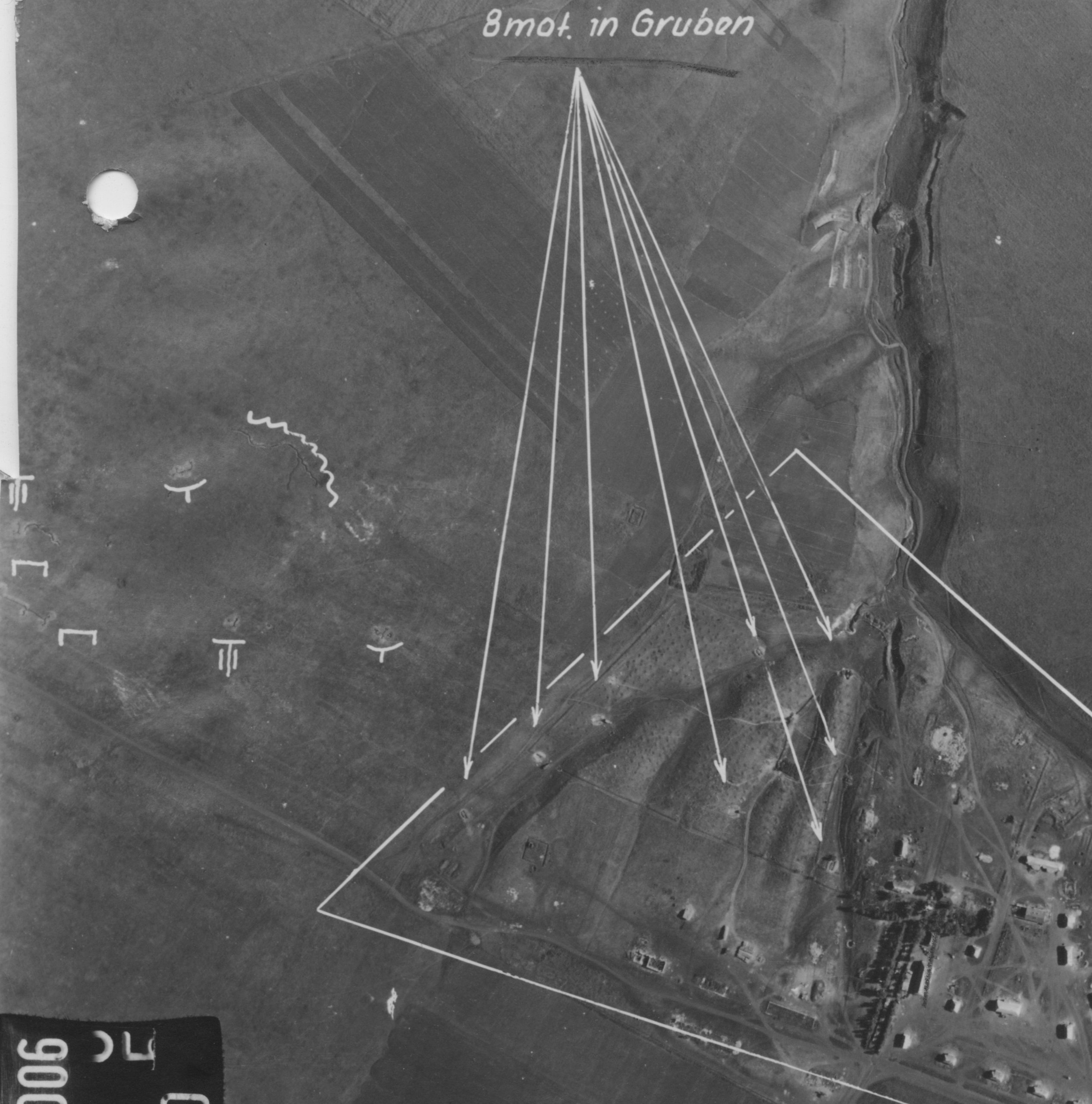
They are drawing their ASL maps from German aerial photographs of the battlefield. The game map covers the area around Oktyabrskii State Farm and height 252.2, part of the tank fields of Prokhorovka. The road to Prokhorovka runs down the right edge of the map. One the previous map, Storozhevoye, is some 3 1/2 kilometers south of height 252.2. This is an aerial photograph of Oktyabrskii State Farm.
The link to their game board is below. Just click on it and the game board should appear.
PROKHOROVKA! – Tank Fields BOARD
The road running down the right edge of the board it the road to Prokhorovka, heading northeast. Also worth looking at is the 1:50000 scale map M 37-26C in my Kursk and Prokhorovka books. The area is mostly in between the grid lines 35 and 37 and 55 to 58 (six square kilometers).
Now, I have looked their work, but I am hardly the right person to conduct photo analysis. Still, it looked pretty good to me. If anyone has any comments, criticisms, recommendations, corrections, edits, and so forth for this map, please let me know. I will forward the comments to them.
Now, I never walked the ground right around Oktyabrskii Sovkhoz. It was still a working farm when I first toured the battlefield in 1995. But you could see it from height 252.2.
Thanks.
Other Photos:
And a photo from my books:
Other references:

I see this post has been up for a while now, but I just noticed it.
There’s been a lot of ink spilled about the Tank Ditch. (It is an interesting subject.) Is it depicted on this game map? I see a lot of lines that look like trenches; I don’t know if that’s what they represent, or if that could be the tank ditch. Or, is the tank ditch the dark line (road?) that runs left to right in a ravine around the middle of map?
Also, are the photos in this post oriented with North at the top? I’m having a hard matching them up with other maps and diagrams.
Yes, the A-T ditch is the thick dark brown line in the middle of the map, the others lines are trenches in their original locations, as per the air recon images.
The photos are both oriented with North at the top, the maps are oriented with North-east at the top, except Andreevka-Vasilyevka that is with North at the top, and Stalinsk branch of OSF map that has East at the top.
OK, I see. Very cool. Thanks! I’m looking forward to these scenarios–I’m curious how the rules will handle the ditch.
From what I have seen you have done a very good job placing the infrantry trenches, minor roads and the anti-tank ditch in the ‘tank field’ area. PS, I enjoyed reading the game’s blurb on your website 😉
Hi everyone,
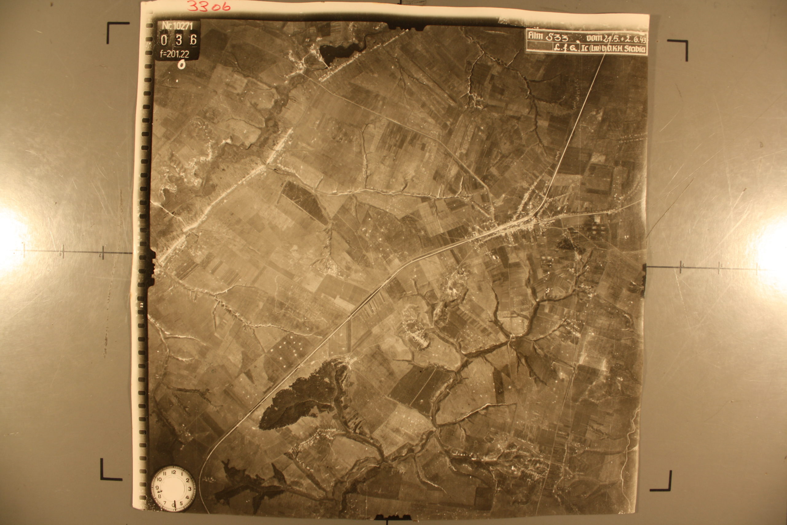
I was very pleasantly surprised to see the aerial map of prokhorovka (33ob, N. 10271, 036 f = 201.22 …). I am fond of military modeling and my next project is a 1/72 reproduction of the battle that took place on July 12, 1943. Would it be possible to get a higher resolution one?
Thank you.
There are dozens of pictures of the area. They are located in the National Archives in Maryland (near DC). I do have a couple of higher resolution ones in my book, but it really depends on what you need and what you are looking for.